![](/images/other/stat-length.png)
![Trail Walking La Neuville-Chant-d'Oisel - La Neuville-Chant-d'Oisel - PT - Photo](https://media.geolcdn.com/t/1900/400/ext.pjpeg?maxdim=2&url=https%3A%2F%2Fstatic1.geolcdn.com%2Fsiteimages%2Fupload%2Ffiles%2F1553511878bg_sport_marche.png)
La Neuville-Chant-d'Oisel - PT
philippe76
User
![Length](/images/other/stat-length.png)
Length
7.5 km
![Max alt](https://static1.geolcdn.com/siteimages/upload/files/1508320355ic_sort_altitude_max_24dp.png)
Max alt
161 m
![Uphill gradient](https://static1.geolcdn.com/siteimages/upload/files/1508320355ic_sort_den_pos_24dp.png)
Uphill gradient
55 m
![Km-Effort](/images/other/stat-length.png)
Km-Effort
8.2 km
![Min alt](https://static1.geolcdn.com/siteimages/upload/files/1508320355ic_sort_altitude_min_24dp.png)
Min alt
136 m
![Downhill gradient](https://static1.geolcdn.com/siteimages/upload/files/1508320355ic_sort_den_neg_24dp.png)
Downhill gradient
54 m
![Boucle](https://static1.geolcdn.com/siteimages/upload/files/16400158638029165_repeat_loop_refresh_sync_direction_icon.png)
Boucle
Yes
Creation date :
2024-10-13 08:10:33.774
Updated on :
2024-10-13 08:38:51.339
![Walking](https://static1.geolcdn.com/sitytour/trail-icons/101.png)
1h52
Difficulty : Medium
![Scan this QR Code to open this trail in the SityTrail application](https://capi.geolives.com/qq0zvz2zws4bq2lad0pu/sitytour/trails/4223897/qr.png?size=200)
FREE GPS app for hiking
About
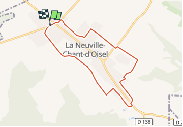
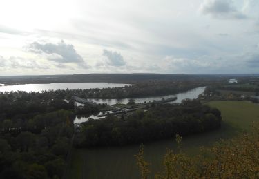
Trail Walking of 7.5 km to be discovered at Normandy, Seine-Maritime, La Neuville-Chant-d'Oisel. This trail is proposed by philippe76.
Description
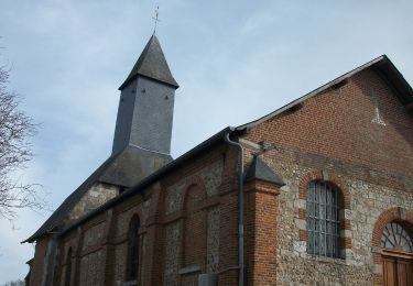
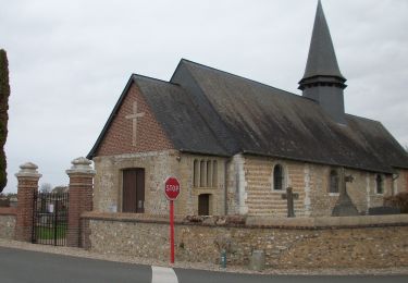
Départ de l'église de La Neuville-Chant-d'Oisel .
Aller jusqu'au château de La Neuville-Chant-d'Oisel, et à la stèle, lieu de mémoire de Jacques Anquetil.
Arrivée à l'église de La Neuville-Chant-d'Oisel.
Positioning
Country:
France
Region :
Normandy
Department/Province :
Seine-Maritime
Municipality :
La Neuville-Chant-d'Oisel
Location:
Unknown
Start:(Dec)
Start:(UTM)
371614 ; 5470340 (31U) N.
Comments
Trails nearby
![Trail Walking Saint-Aubin-Épinay - Saint Aubin-Epinay - Epinay vers Franqueville - Photo](https://media.geolcdn.com/t/375/260/ext.jpg?maxdim=2&url=https%3A%2F%2Fstatic1.geolcdn.com%2Fsiteimages%2Fupload%2Ffiles%2F1553511878bg_sport_marche.png)
![Walking Walking](https://static1.geolcdn.com/sitytour/trail-icons/101.png)
Saint Aubin-Epinay - Epinay vers Franqueville
Walking
Medium
(1)
Saint-Aubin-Épinay,
Normandy,
Seine-Maritime,
France
![](/images/other/stat-length.png)
10.1 km | 12 km-effort
2h 37min
![](https://static1.geolcdn.com/siteimages/upload/files/16400158638029165_repeat_loop_refresh_sync_direction_icon.png)
Yes
![Trail Walking Ymare - Ymare - Photo](https://media.geolcdn.com/t/375/260/ext.jpg?maxdim=2&url=https%3A%2F%2Fstatic1.geolcdn.com%2Fsiteimages%2Fupload%2Ffiles%2F1553511878bg_sport_marche.png)
![Walking Walking](https://static1.geolcdn.com/sitytour/trail-icons/101.png)
Ymare
Walking
Very easy
(1)
Ymare,
Normandy,
Seine-Maritime,
France
![](/images/other/stat-length.png)
8.9 km | 10.6 km-effort
2h 0min
![](https://static1.geolcdn.com/siteimages/upload/files/16400158638029165_repeat_loop_refresh_sync_direction_icon.png)
Yes
![Trail Walking Pont-Saint-Pierre - 27-03-Flipou Pont Saint Pierre 14km-486-478- - Photo](https://media.geolcdn.com/t/375/260/5f192092-f3eb-4914-a0dc-a7ccf7ccb6ff.jpg&format=jpg&maxdim=2)
![Walking Walking](https://static1.geolcdn.com/sitytour/trail-icons/101.png)
27-03-Flipou Pont Saint Pierre 14km-486-478-
Walking
Difficult
(1)
Pont-Saint-Pierre,
Normandy,
Eure,
France
![](/images/other/stat-length.png)
13.7 km | 18.8 km-effort
4h 21min
![](https://static1.geolcdn.com/siteimages/upload/files/16400158638029165_repeat_loop_refresh_sync_direction_icon.png)
Yes
![Trail Walking Pont-Saint-Pierre - 20240409-Flipou - Photo](https://media.geolcdn.com/t/375/260/88d68366-9846-42f8-8298-7e7b63133a02.jpg&format=jpg&maxdim=2)
![Walking Walking](https://static1.geolcdn.com/sitytour/trail-icons/101.png)
20240409-Flipou
Walking
Medium
Pont-Saint-Pierre,
Normandy,
Eure,
France
![](/images/other/stat-length.png)
12.4 km | 15.3 km-effort
3h 52min
![](https://static1.geolcdn.com/siteimages/upload/files/16400158638029165_repeat_loop_refresh_sync_direction_icon.png)
Yes
![Trail Walking Quévreville-la-Poterie - 20240104-Quevreville la Potterie - Photo](https://media.geolcdn.com/t/375/260/0b8d8346-6b3b-4e80-8d5c-b85557b11606.jpg&format=jpg&maxdim=2)
![Walking Walking](https://static1.geolcdn.com/sitytour/trail-icons/101.png)
20240104-Quevreville la Potterie
Walking
Medium
Quévreville-la-Poterie,
Normandy,
Seine-Maritime,
France
![](/images/other/stat-length.png)
9.2 km | 11.2 km-effort
2h 43min
![](https://static1.geolcdn.com/siteimages/upload/files/16400158638029165_repeat_loop_refresh_sync_direction_icon.png)
Yes
![Trail Walking Quévreville-la-Poterie - 20231219-quevreville noel - Photo](https://media.geolcdn.com/t/375/260/9039af00-539b-4ef5-83fe-9bd657e6d749.jpg&format=jpg&maxdim=2)
![Walking Walking](https://static1.geolcdn.com/sitytour/trail-icons/101.png)
20231219-quevreville noel
Walking
Medium
Quévreville-la-Poterie,
Normandy,
Seine-Maritime,
France
![](/images/other/stat-length.png)
10.3 km | 12.6 km-effort
2h 55min
![](https://static1.geolcdn.com/siteimages/upload/files/16400158638029165_repeat_loop_refresh_sync_direction_icon.png)
Yes
![Walking Walking](https://static1.geolcdn.com/sitytour/trail-icons/101.png)
20231024-Pont-St-Pierre
Walking
Difficult
Pont-Saint-Pierre,
Normandy,
Eure,
France
![](/images/other/stat-length.png)
10.1 km | 13.3 km-effort
3h 20min
![](https://static1.geolcdn.com/siteimages/upload/files/16400158638029165_repeat_loop_refresh_sync_direction_icon.png)
No
![Walking Walking](https://static1.geolcdn.com/sitytour/trail-icons/101.png)
20230221-Fresne Le Plan
Walking
Medium
Fresne-le-Plan,
Normandy,
Seine-Maritime,
France
![](/images/other/stat-length.png)
13.5 km | 15.3 km-effort
3h 22min
![](https://static1.geolcdn.com/siteimages/upload/files/16400158638029165_repeat_loop_refresh_sync_direction_icon.png)
Yes
![Walking Walking](https://static1.geolcdn.com/sitytour/trail-icons/101.png)
20230216-Ymare Claude
Walking
Medium
Ymare,
Normandy,
Seine-Maritime,
France
![](/images/other/stat-length.png)
12.2 km | 14.1 km-effort
3h 17min
![](https://static1.geolcdn.com/siteimages/upload/files/16400158638029165_repeat_loop_refresh_sync_direction_icon.png)
Yes